What's new

If that last storm damaged Gold Base...

Dulloldfart

Squirrel Extraordinaire
The Int base property is very flat and there is no downhill from there. When it rains hard, it floods. Everything on the south side of the road will be at least partially underwater. Guaranteed.

If there is still bare ground from all the illegal clearing that was done, Int base will be "pulling it in bigtime". :biggrin:

Will the Dwarf order all the buildings to be redone, but on stilts this time?

5704237-Houses_on_Stilts-0.jpg


Paul
 

Gizmo

Rabble Rouser
Maybe a few will live through this disaster?

How many lives were lost in these massive mudslides out there ?
 

whoisxenu

Patron with Honors
"How many lives were lost in these massive mudslides out there ?"

Sad to say the FIFTH INVADER FORCE is now the 4.235 INVADER FORCE. :bigcry: Thetans everywhere are reaching for the frozen booze and glycol.
 
Such a romantic name, Massacre Canyon Inn, puts me off my food though.

FYI~

From: http://www.pe.com/articles/canyon-675559-massacre-san.html

BACK IN THE DAY: Massacre Canyon named for Indian battle
The fight pitted Temecula Indians against those of the village of Ivah, located near what’s now Gilman Hot Springs

BY STEVE LECH / COLUMNIST Published: Aug. 16, 2013 12:38 p.m.

Massacre Canyon Falls as it appears today. Spring water feeds the falls, which can be seen throughout the year.

n22aoa-rhistory0818abinary1147952.jpg

STEVE LECH, FREELANCE PHOTOGRAPHER

"Massacre Canyon is a small, flat rift in the otherwise hilly and steep Badlands area of Riverside County. Characterized by very high, steep sides, the canyon is located just northwest of Gilman Hot Springs, along Highway 79 between Lamb's Canyon Road and San Jacinto. A perennial stream runs through it, fed by springs on the Portrero southwest of Beaumont.

The stream enters Massacre Canyon on the north at Massacre Canyon Falls, where it falls over a 12-foot wall of solid rock to continue on through the canyon and out onto the San Jacinto plain. While most people do not know of its existence, the history behind it is an indelible part of the lore of the San Jacinto Valley.

Massacre Canyon got its name during the earliest days of American settlement in the San Jacinto Valley. According to Rena Fowler, who wrote a history of the San Jacinto Valley in 1912, many of the local Soboba Indians told of a battle that pitted Temecula Indians against those of the village of Ivah, located near the present community of Gilman Hot Springs.

Old Victoriano, the last of the hereditary chiefs of the Soboba Indians, related the story of how one day the Temeculas were seen gathering seeds from the Chia plant in areas of the San Jacinto Valley claimed by the Ivahs. The Chia plant, identified as Salvia Columbariae by David Prescott Barrows, grew in many parts of western Riverside County.

The seeds were an important food source, and when the plant failed in the Temecula Valley because of drought, the Temeculas sought it elsewhere. A high-ranking contingent was sent from Ivah to put a stop to the incursion, but discussions to alleviate the problem broke down when one of the Temeculas shot at the Ivahs.

The two sides then prepared for combat, and met the next day in battle. For most of the day the battle raged on, claiming the lives of many on both sides. However, when the Temeculas received reinforcements late in the day, the Ivahs retreated into what is now called Massacre Canyon.

The tall, steep walls of the canyon afforded no exit, and the Ivahs continued to retreat. Approximately one-half mile into the canyon is Massacre Canyon Falls, and the walkable portion of the canyon comes to an abrupt end in what can only be described as a room, enclosed on three sides by shear, dark rock walls. These shear walls trapped the remaining Ivahs and, according to Mrs. Fowler, the Ivahs fought to the death, a fight in which the victor gave no mercy, the vanquished sought none.

Hearing the story some 350 years later from many of the local Sobobas, the early American residents of the San Jacinto Valley dubbed the area Massacre Canyon.

During the heyday of Gilman Hot Springs, Massacre Canyon was a popular outing for a day trip. Today, people can be found hiking along the streambed or attempting to climb the steep sides, although that exercise can be particularly dangerous and a few people have been injured or even killed trying. I go for the falls and the view and stay off the sides!"

I've been there, it's pretty in the Spring, with water and wildflowers!:thumbsup:
 

Type4_PTS

Diamond Invictus SP
I never would try to escape through mud - and I would not recommend it to anyone. The chances for a success are to low.


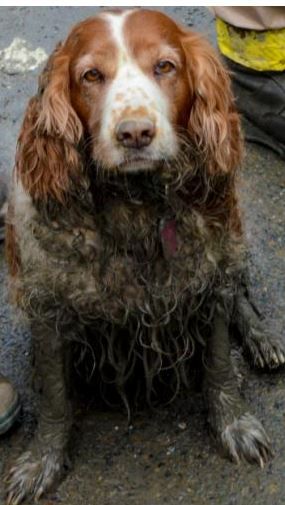
One of DM's dogs would disagree with you.

He took advantage of the broken perimeter fence during the mudslide to make his move.

dog_zps43be5ec7.jpg
 

Rmack

Van Allen Belt Sunbather
There was never a 'San Jacinto Country Club' that I'm aware & it's not mentioned in the book. You are probably thinking of the the Gilman Hot Springs resort. From Bent's book:

"In October of 1978, another facility had been purchased. It was known as Gilman Hot Springs and included that resort and a motel known as the Massacre Canyon Inn, about 20 miles west of Palm Springs. Gilman Hot Springs included a 27-hole golf course and a variety of other facilities.... Additionally, there are strong indications that a group now occupying the former Gilman Hot Springs resort, near San Jacinto, may be a Scientology project."

http://www.xenu.net/archive/books/mom/Messiah_or_Madman.txt

http://articles.latimes.com/2005/dec/18/business/fi-scientologyside18

OK, well where the hell did I land back in the late Eighties? There was definitely a golf course, a pool, a bar, (with a bunch of very happy old guys who gave me a beer, change for the pay phone, etc) and access to the road, where my chase crew picked me up. I folded up my diver by the pool, and a bunch of kids asked me questions about hang gliding. The wedding practice didn't seem to like me. I landed somewhere.

Probably there, 'Gilman Hot Springs'. So, what happened to it? Did it get assimilated?
 

Rmack

Van Allen Belt Sunbather
LOL ! Ankle deep mud ain't deep for even the most mired clam !

How did this make that leap to some conclusion of car deep avalanches of mud slides in the worst parts ?

I'm not suggested braving life endangering mud slides but merely walking out through a little slush...... but you image was dramatic !

Or is it all buried & all trapped in with life threatening circumstances of mud all over everywhere car deep & deeper all over the whole joint ?

Thank you for sharing!
 

Rmack

Van Allen Belt Sunbather
"How many lives were lost in these massive mudslides out there ?"

Sad to say the FIFTH INVADER FORCE is now the 4.235 INVADER FORCE. :bigcry: Thetans everywhere are reaching for the frozen booze and glycol.
When the Glycol runs short, the revolution will begin...
 

Little David

Gold Meritorious Patron
OK, well where the hell did I land back in the late Eighties? There was definitely a golf course, a pool, a bar, (with a bunch of very happy old guys who gave me a beer, change for the pay phone, etc) and access to the road, where my chase crew picked me up. I folded up my diver by the pool, and a bunch of kids asked me questions about hang gliding. The wedding practice didn't seem to like me. I landed somewhere.

Probably there, 'Gilman Hot Springs'. So, what happened to it? Did it get assimilated?
Maybe the Soboba Country Club?:
n22jwt-radultswin0702binary1086503.

clubhouse.jpg
soboba.jpg
 

Little David

Gold Meritorious Patron
My flight was in the mid-eighties, what was there back then?
In December of 2004, the Soboba Band of Luiseno Indians purchased Soboba Springs Royal Vista Golf Club from the Honolulu based company, Waterhouse, Inc. It was always a dream of the tribal leaders to own the beautiful golf course that bordered their reservation.

Immediately, they began planning development of the golf course site to return the facility to the premier golf destination in Southern California and beyond.

They contracted the services of Cary Bickler, golf course architect and disciple of Desmond Muirhead, the original golf course designer in 1966.

http://www.sobobaspringscc.com/history
 

Rmack

Van Allen Belt Sunbather
In December of 2004, the Soboba Band of Luiseno Indians purchased Soboba Springs Royal Vista Golf Club from the Honolulu based company, Waterhouse, Inc. It was always a dream of the tribal leaders to own the beautiful golf course that bordered their reservation.

Immediately, they began planning development of the golf course site to return the facility to the premier golf destination in Southern California and beyond.

They contracted the services of Cary Bickler, golf course architect and disciple of Desmond Muirhead, the original golf course designer in 1966.

http://www.sobobaspringscc.com/history

OK, sounds like it was 'Soboba Springs Royal Vista Golf Club' that I landed at. I've just always thought of it as the San Jacinto Country Club, as the old guys at the bar characterized it that way, as I recall.

They thought it was a hoot when I asked 'Where am I?'. After telling the story, they bought me beers, and when I bummed change for the phone, they pushed about ten bucks worth on me, hehe.
 
Ah shoot, another auto fatality on Gilman Springs Road! :no:

From: http://www.pe.com/articles/one-756352-wreck-caltrans.html

nglifl-pewmvfatal1215tlpa.jpg


ngli7t-pewmvfatal1215tlpe.jpg


"Traffic is backed up in both directions on Gilman Springs Road after the fatal head-on crash near Quail Ranch Golf Club on Sunday, Dec. 14, 2014.
TERRY PIERSON, STAFF PHOTOGRAPHER

Riverside County fighters and CHP officers investigate a fatal head-on crash on Gilman Springs Road on Sunday, Dec. 14, 2014.

BY RICHARD BROOKS / STAFF WRITER Published: Dec. 14, 2014 Updated: 3:42 p.m.

A head-on crash killed one person and jammed a major road between Moreno Valley and San Jacinto, according to the California Highway Patrol and Caltrans websites.

The wreck was reported at 11:31 a.m. Sunday, Dec. 14, along Gilman Springs Road near Quail Ranch Golf Club, east of Mystic Lake and about a half-mile north of Jack Rabbit Trail.

It involved a blue Honda Civic and a red Honda Accord. One person in the Civic died at the scene. Three people suffered major injuries and two were unhurt, Cal Fire/Riverside County Fire Department officials wrote in an incident report. Two people — one from each vehicle — had to be cut from the wreckage, fire officials said.

An hour after the wreck, the backup stretched for about a mile, according to the Caltrans Quickmap. California Highway Patrol officers are investigating the cause of the crash."
 

Rmack

Van Allen Belt Sunbather
Ah shoot, another auto fatality on Gilman Springs Road! :no:

From: http://www.pe.com/articles/one-756352-wreck-caltrans.html

nglifl-pewmvfatal1215tlpa.jpg


ngli7t-pewmvfatal1215tlpe.jpg


"Traffic is backed up in both directions on Gilman Springs Road after the fatal head-on crash near Quail Ranch Golf Club on Sunday, Dec. 14, 2014.
TERRY PIERSON, STAFF PHOTOGRAPHER

Riverside County fighters and CHP officers investigate a fatal head-on crash on Gilman Springs Road on Sunday, Dec. 14, 2014.

BY RICHARD BROOKS / STAFF WRITER Published: Dec. 14, 2014 Updated: 3:42 p.m.

A head-on crash killed one person and jammed a major road between Moreno Valley and San Jacinto, according to the California Highway Patrol and Caltrans websites.

The wreck was reported at 11:31 a.m. Sunday, Dec. 14, along Gilman Springs Road near Quail Ranch Golf Club, east of Mystic Lake and about a half-mile north of Jack Rabbit Trail.

It involved a blue Honda Civic and a red Honda Accord. One person in the Civic died at the scene. Three people suffered major injuries and two were unhurt, Cal Fire/Riverside County Fire Department officials wrote in an incident report. Two people — one from each vehicle — had to be cut from the wreckage, fire officials said.

An hour after the wreck, the backup stretched for about a mile, according to the Caltrans Quickmap. California Highway Patrol officers are investigating the cause of the crash."

I wonder if the flood damage had anything to do with this. Can you imagine the siege mentality going on at Gold right now?
 

HelluvaHoax!

Platinum Meritorious Sponsor with bells on
I wonder if the flood damage had anything to do with this. Can you imagine the siege mentality going on at Gold right now?


I would imagine that if all of the elite Gold staff members were surveyed, more than 80% would answer with certainty that the mudslides were a motivator in some way related to previous overts.

Seriously.
 

Rmack

Van Allen Belt Sunbather
The only actual interaction with Gold that ever had (besides hang gliding nearby) was when I was on the way to a job installing OnCommand systems in Hotels. Yeah, I was technically a porn monger! I quit.

Anyway, I was passing through this area that we are discussing on the way to a job, and it started raining, and one of my windshield wipers malfunctioned. We pulled off the road at the first large enough area, which just happened to be close to this big Castle-looking structure. As we repaired the wiper, I saw security cameras turning towards us. It was worth a laugh.

We got it working, and drove on.

That building was down right spooky. It was a weird color. It had fake castellations that gave it a medieval look. It had few, if any, windows, and those seemed to be blocked.

That combined with the watching cameras was enough to creep you out, which I'm sure was the purpose.
 
Top